By Glen Wunderlich’
Member Professional Outdoor Media Association (POMA)
Squatter’s rights is a term for an underhanded maneuver many of us have heard about recently. The process typically involves people moving into or onto someone else’s property without authorization. Legally getting them to leave is a burden the owner must bear and I speak from current experience.
These flighty migrants have big plans to raise their family on some prime real estate, as well. Oh, sure, I can kick them out forcefully but the law protects them, and so doing would paint me as an outlaw. However, I have inside information that they’ll all be moving shortly, so no hasty action is necessary.
I’ve been relegated to peer through a binocular at a safe distance in an effort to avoid confrontation. These bird-brained loudmouths have screamed at me for all they’re worth, but I’ve seen their kind for decades. It’s best to wait them out while the process evolves. Yes, Killdeer are quite predictable!
These upland shorebirds in the Plover family place their nests inconspicuously camouflaged in the middle of one’s gravel driveway – or, as in my example, in the midst of my melon garden. No melons are forthcoming this year, even though the seeds were planted weeks ago, because they’ve received no rainwater. Although a hand-pump has been installed as a handy water source next to the remote garden, I’ll not become a disrupting force for the sake of some melons. (Heck, my new Ketogenic diet doesn’t allow the sweet stuff anyway, but I know of some youngsters that’ll be disappointed.) See the culprits here: Killdeer and Nest – YouTube
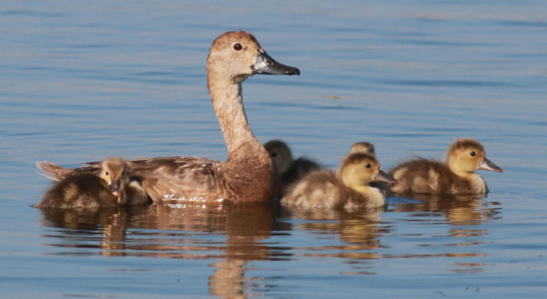
Because both adult birds take part in the nesting cycle, including incubation, the blistering heat we’ve experienced can be minimized by egg-sitting in shifts. The hatchlings won’t appear for some 24 to 28 days, which is longer than most of our wild birds. However, when they get their first glimpse of daylight, and then dry off, they’ll leave the nest on a fast march in tow with their parent(s). These newborn chicks are pre-programed to find food and will follow their parents pecking the ground for insects and won’t become airborne for a few weeks.
Even though their “bark” may be more potent than their bite, they’ll defend the nest or chicks ferociously, if the ol’ broken wing trick fails to draw one’s attention away from the vulnerable ground-restricted young. I fell for this trick as a youngster, and it’s quite convincing!
As an example of the adults’ defensive tactics, I had hiked a trail to purposely skirt the occupied nest so as not to bother the Killdeer, when a hen turkey began charging in my direction and squawking all the way. Its focus was sharply pointed at me, when the tiny Killdeer sprang from its nest and vigorously attacked the massively larger hen turkey with an air assault, as it ventured too close to its eggs on the ground. This mother turkey was obviously in defense of her own eggs or chicks and took the energetic punishment, before turning away from me and returning to its precious family in-the-making.
As far as the Killdeer are concerned, I appreciate their appetite for insects and their antics that are heard well into the night – even if it means they’ve taken my land through adverse possession.