Affected area is Lake Superior shoreline from Gay to Grand Traverse Harbor
The Michigan Department of Environment, Great Lakes and Energy’s Water Resources Division, in cooperation with the Buffalo Reef Task Force, is asking property owners to report underground features, like onsite septic systems and water and irrigation lines, along a 5-mile stretch of Lake Superior shoreline in Keweenaw County.
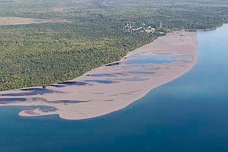
Over the past few years, the task force has been working to remove dark-colored stamp sands from the beach between the community of Gay and Grand Traverse Harbor.
The stamp sands were deposited into Lake Superior and on the beach at Gay during historic copper stamp mill processing from the Wolverine and Mohawk mines. Ore was crushed by the stamps and the copper separated through a flotation process. Stamp sands are the waste material resulting from the milling work.
Over the past roughly 80 years, the stamp sands have shifted south – moved by winds, waves and nearshore lake currents – about 5 miles to the Grand Traverse Harbor, covering 1,426 acres of shoreline and lake bottom.
“Without taking measures to slow the movement and down-drift accumulation of the stamp sands, they will eventually move past the harbor and deposit on the natural white sand beach south of the jetty, at the mouth of the Traverse River,” said Steven Check, a project manager with the U.S. Army Corps of Engineers in Detroit.
The sands threaten Buffalo Reef, a natural underwater structure important to lake trout and lake whitefish.
Providing information to EGLE about the underground infrastructure located on beach properties will help analysts develop strategies to remove more of the stamp sands. Options currently being considered include removal of all or some of the stamp sands along the beach.
“The multi-agency task force understands that whatever is option is selected, it most likely will have social and economic impacts,” said Jay Parent, district supervisor of EGLE’s Water Resources Division in Marquette. “This is why it is important for us to hear from affected property owners.”
Property owners were sent letters this week explaining the situation. They are being asked to tell the task force whether underground features are present. If they are, the task force requests property owners provide the property parcel identification number, type of underground features possibly affected and include a map showing the approximate location of that infrastructure.
Property owners with questions or concerns about the issue may call Jay Parent at 906-236-9611 or by email at parentj@michigan.gov
The Buffalo Reef stamp sands removal project, funded through the Great Lakes Restoration Initiative and a state of Michigan appropriation, is being executed in cooperation with the U.S. Army Corps of Engineers, U.S. Environmental Protection Agency, Keweenaw Bay Indian Community, the Great Lakes Indian Fish and Wildlife Commission, the Michigan Department of Natural Resources and the Michigan Department of Environment, Great Lakes and Energy to save the 2,200-acre reef.
For more information on the ongoing effort to save Buffalo Reef, or to sign-up for the latest email updates, visit Michigan.gov/BuffaloReef.