Most birds migrate at night, including many species of waterfowl, such as Northern Shovelers (photo by Paul Konrad).
A screenshot of a BirdCast bird migration map resembles a radar screen. This screenshot is dated April 1st at 4:20am EDT.
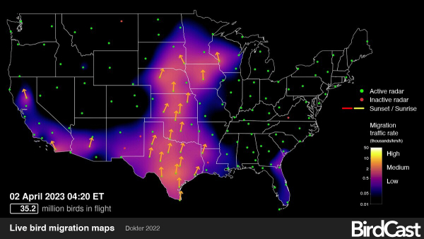
Spring migration brings a number of high-tech options for birders to use online when planning birding trips and to keep in touch with bird migration across the Lower 48 States. BirdCast provides migration forecasts that show predicted nocturnal migration activities for tonight and the next 2 nights. You can also see real-time BirdCast migration maps that show intensities of nocturnal bird migration as detected by the US weather surveillance radar network between sunset and sunrise each night.
Nocturnal Bird Migration Radar Maps – BirdCast real-time analysis maps show intensities of color-coded radar movements throughout the nighttime hours as detected by the US weather surveillance radar network from sunset to sunrise across the Lower 48 States. The migration movements progress with time, with a red line that moves east to west to show the timing of local sunset, followed by colored flight patterns detected by the radar, and a yellow line moves across the states to show the progression of sunrise.
Bird migration intensity is indicated on the maps with areas showing a range of colors from purple and blue for light migration rates and lighter colors where higher migration rates are detected. Brighter colors indicate a higher migration rate, expressed in units of birds per kilometer per hour. Orange arrows also show the directions birds were flying.
You can now monitor the maps daily, weekly, or whenever you think of it during this spring migration season at Live bird migration maps – BirdCast including access to the library of past migration maps for any date during present and past spring and fall migrations.
Bird Migration Forecast Maps – BirdCast also provides migration forecasts that show predicted nocturnal migration for tonight and the 2 following nights. The Global Forecasting System is used to predict suitable conditions for migration 3 hours after local sunset with updates every 6 hours. Produced from models created with information collected during the past 23 years of bird movements in the atmosphere as detected by the US NEXRAD weather surveillance radar network, Colorado State University and the Cornell Lab of Ornithology are producing these interesting and insightful forecasts. To access Bird Migration Forecast Maps for the next 3 nights in any county or state in the Lower 48, refer to Bird migration forecast maps – BirdCast