By JOHN PEPIN Deputy public information officer Michigan Department of Natural Resources
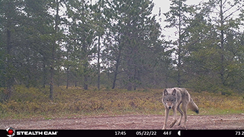
On a desolate two-track road, a man approaches on a snowmobile.
Watching the road ahead, he notices a line of tracks in the snow that lead from a dense stand of trees along a creek. The man stops the sled and as it idles, he leans over for a better view.
He’s found what he’s looking for – gray wolf tracks.
The man is wildlife technician, part of this winter’s Michigan Department of Natural Resources survey of wolves in the Upper Peninsula.
Researchers from the DNR use snowmobiles and trucks to search about 60% of the region for tracks and other signs of wolf activity and occupancy of specified study areas.
“We are continuing the 2024 winter estimate as long as we can despite the very low snowfall this winter,” said Brian Roell, a DNR wildlife biologist and the department’s wolf specialist. “We are approximately 75-80% completed.”
The lower snowfall amounts this winter have made it harder to find wolf tracks.
The DNR alternates wolf surveys every other winter with efforts to produce moose population estimates.
Methods and measures
The previously most recent wolf track survey, conducted during early 2022, resulted in a wolf minimum population estimate of 631, and an estimated 136 wolf packs.
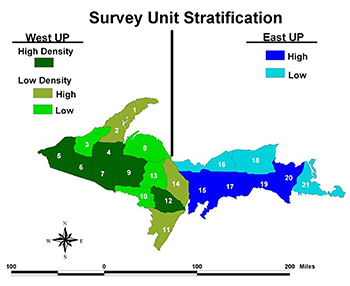
In the western U.P., researchers have found the highest densities of wolves in primarily the counties bordering Wisconsin and the southernmost counties in the eastern U.P.
Over recent years, as wolves have become more widely established in the region and their numbers have risen, wolf surveys have become more challenging for researchers.
“The current minimum count requires significant effort to provide an index of abundance,” said Tyler Petroelje, a DNR wildlife researcher. “As wolf density has increased, more time is needed to discern adjacent packs.”
Petroelje said the track survey method does not account for imperfect detection (places deemed unoccupied that are occupied) of wolves nor does it provide a confidence interval, indicating how statistically accurate the minimum population estimate is.
Efforts begun in 2022 to research alternative methods to estimate wolf abundance are still underway in the U.P. and are expected to continue through 2027.
“We are looking to increase precision and decrease costs,” Petroelje said.
The team involved in the ongoing joint DNR-Michigan State University project includes veterans of a predator-prey study conducted from 2009 to 2019 in low, medium and high snowfall zones in the U.P.
The wildlife biologists and researchers on the new wolf abundance project include Brian Roell and Petroelje at the DNR and Jerrold Belant, J. Matt Nelson and Dean Beyer at Michigan State.
Alternatives
In the project’s early stages, researchers dismissed some potential means to survey wolves because of inherent problems.
Aerial surveys are not used because of the significant area to study and extensive forest cover that makes finding wolves difficult.
Wolf howling surveys have a low response rate, and detection requires significant time investment to estimate wolf abundance.
However, researchers championed a couple of other ideas, including modifying the current track survey to account for imperfect detection and using game cameras and artificial intelligence to acquire and sort wolf images, respectively.
“Breakthroughs in machine learning allow for rapid classification of remote camera images,” Petroelje said. “It also provides potential to monitor other wildlife species in addition to wolves.”
Researchers sought to evaluate the effectiveness of the occupancy-based track surveys and the efficacy of camera-based surveys, and compare the cost effectiveness of the techniques, considering the potential for monitoring other wildlife species like bobcats, black bears and moose.
Pilot surveys
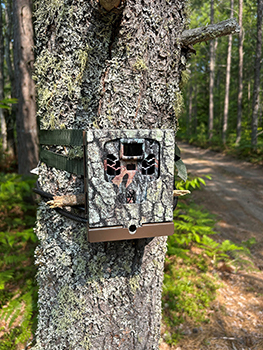
In 2022, a pilot project using a camera survey was conducted over portions of Marquette, Alger, Delta and Schoolcraft counties.
Researchers put up 200 trail cameras over 40 contiguous, hexagon-shaped cells each covering an area of 62 square miles. The distribution produced a density of one camera for every 12.5 square miles.
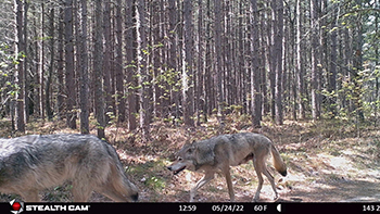
Over a period of three months, the cameras captured 1.7 million images.
An artificial intelligence program called RECONN.AI was able to positively identify and sort various animal images from the photographs. This software also blurs images of people and vehicles to protect personally identifiable information.
The analysis showed the cameras had captured 40,323 photos of white-tailed deer, 7,534 black bear, 4,221 wolf, 2,936 coyote, 2,823 sandhill crane, 2,315 red fox and 764 bobcat.
For comparison, a 2022-2023 pilot snow track survey was conducted over the same geographic area.
Trucks and snowmobiles traveled over 756 miles of roads in the area looking for wolf tracks, with an average of 19 miles of roads in each of the survey area cells. In all, 2,268 miles were driven with 119 observations of wolf tracks made.
Researchers said this second method was more time-consuming, weather-dependent and difficult to scale upward to cover the entire U.P.
Scaling up
A preliminary analysis of the results of the camera pilot project demonstrated the need for some changes, including increasing the size of the cells to match the annual home territory of wolves tracked with GPS collars and decreasing the density of cameras.
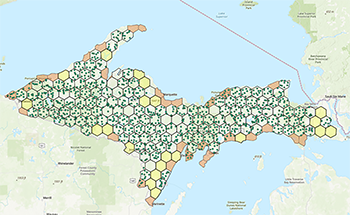
A camera grid was created to cover the entire U.P. with 202 hexagonal cells measuring 130.5 square miles each. Eight cameras were to be deployed for each cell, resulting in one camera for every 16 square miles.
Twenty-two cells were excluded from camera placement because land parcels represented only partial cells, while another 21 cells were also excluded because the land was made up mostly of city or private ownership.
A total of 1,230 trail cameras were set out over 159 cells.
The cameras were placed on tree trunks at a height of 4.5 feet from the ground, along the nearest accessible road or trail near predetermined points, with wolves habitually traveling trails and roads with low use.
Cameras were placed facing generally north, with a notice posted to passersby about the wildlife research purpose of the cameras.
Full camera deployment is planned for the next two years. Those deployed in 2023 will be revisited in 2024 and 2025.
The future
Photo analysis using RECONN.AI will continue this year and next to generate a wolf abundance estimate for the U.P.
“Annual reports will be made available to the public,” Petroelje said. “A public-facing website will also be created with interactive capabilities to view results.”
After 2025, full camera deployment will continue to create abundance estimates for not only wolves, but other wildlife species as well.
“The trail camera system will be less expensive because it will cut down on the amount of field time tracking labor,” Roell said. “It can estimate the wolf population at other times of the year, allowing us to move away from a midwinter count.”
Roell said Wisconsin has been using the camera survey method over the past few years, determining that the wolf track survey method produces results within the 95% confidence limits.
“In other words, both methods work and produce very similar results,” Roell said.
Concerns
The ability to generate accurate information on wolf status and abundance in Michigan is important to ongoing hopes of removing gray wolves in our state from the federal List of Endangered and Threatened Species as a recovered species.
Delisting gray wolves now considered threatened or endangered species would allow wolf management decisions to be controlled by states and tribal governments, including the DNR in Michigan.
The DNR supports efforts to delist wolves as a recovered species in Michigan. The U.S. Fish and Wildlife Service, in a response to court decisions, is working to create a national wolf recovery plan.
Though the camera survey method will produce statistically accurate results at reduced human effort and financial costs, cooperation from the public is needed it is to ultimately be effective.
“This new method is expected to provide many benefits, but this is all reliant on if it works for Michigan,” Roell said. “We have already heard about and witnessed a fair amount of camera sabotage damage.”
Check out previous Showcasing the DNR stories in our archive at Michigan.gov/DNRStories. To subscribe to upcoming Showcasing articles, sign up for free email delivery at Michigan.gov/DNREmail.
 The previously most recent wolf track survey, conducted during early 2022, resulted in a wolf minimum population estimate of 631, and an estimated 136 wolf packs.
 In the project’s early stages, researchers dismissed some potential means to survey wolves because of inherent problems.
 In 2022, a pilot project using a camera survey was conducted over portions of Marquette, Alger, Delta and Schoolcraft counties.
 A camera grid was created to cover the entire U.P. with 202 hexagonal cells measuring 130.5 square miles each. Eight cameras were to be deployed for each cell, resulting in one camera for every 16 square miles.
 The ability to generate accurate information on wolf status and abundance in Michigan is important to ongoing hopes of removing gray wolves in our state from the federal List of Endangered and Threatened Species as a recovered species.


