DNR’s nearly four-year intensive land review effort recently completed
By SARAH LAPSHAN
Senior Communications Advisor
Michigan Department of Natural Resources
Three and a half years, nearly 9,800 individual parcels and more than 167,000 total acres comprehensively evaluated by the Michigan Department of Natural Resources – it’s all part of the DNR’s agencywide state land review process that concluded in February with approval of the final group of staff recommendations on which parcels to keep, swap or sell.
It was a massive undertaking prompted by Michigan’s Managed Public Land Strategy (initially developed in 2013), which directs the DNR to evaluate how well the lands under its care contribute to the department’s mission.
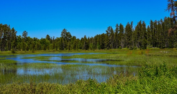
The review focused on two basic types of parcels: those that are either 200 acres or smaller in size or those irregularly shaped with a significant shared private-public boundary that makes them difficult to manage.
Just how much land are we talking about?
Well, all that acreage adds up to roughly 261 square miles, or about the size of 70 Mackinac Islands! Still, it amounts to a review of just over 3.6% of all state-owned land managed by the DNR.
Of that 3.6%, about 15% of the parcels – just over the total size of 10 Mackinac Islands – was approved to be sold, swapped or otherwise divested from state ownership, while 85% of the reviewed land was retained.
Right now, though, you might be wondering how the DNR got into land management. According to DNR forest land administrator Kerry Heckman, it wasn’t entirely by design.
An evolving strategy
In the early 1900s and again during the Depression Era, a significant amount of land came into state ownership due to owners’ nonpayment of taxes. This most often happened after land was stripped of its timber resources or because of farm failures.
Heckman said the department would sell off these tax-reverted parcels only to have them again revert to state ownership due to unpaid taxes – a vicious circle that continued for several years.
“In the 1930s and ’40s, the state decided to try its hand at actively managing the public land that seemed destined to stay under its purview,” she said. “That idea formed the foundation of Michigan’s state forest system and other public land management.”
Land continued to come to the state (specifically the DNR) due to nonpayment of taxes through 1999, when Public Act 123 changed that process and instead directed forfeited land to county governments.
During those decades before the law changed, however, the DNR found itself responsible for a great deal of public land that wasn’t acquired intentionally and didn’t offer much public benefit.
Fast forward to , with a land strategy and review that guide thoughtful decision-making to determine which parcels make sense to keep and which ones don’t meet the DNR mission and can be sold – and the proceeds used to purchase higher-quality, higher-resource value lands.
How did the land review work?
More than 150 staffers across multiple DNR divisions played a role in the review, which was done on a county-by-county basis, 10 to 11 geographically dispersed counties at a time.
All the land parcels went through a thorough multilevel, multidisciplinary evaluation:
Local: The review process started with local forest unit managers, wildlife and fisheries biologists and recreation specialists.
Regional: Next, forestry, wildlife, fisheries and recreational aspects were considered through a regional lens.
Statewide: The same aspects – forestry, wildlife, fisheries and recreation – were viewed from the statewide level.
By program: Important issues such as mineral rights, deed restrictions and environmental effects were reviewed by the DNR and the state Department of Environment, Great Lakes, and Energy.
With so many people at the table, advocating for different resources and recreation opportunities, debate was frequent and well-intentioned.
Kasey Cline, Cadillac District supervisor with DNR Parks and Recreation, had a unique perspective.
“I took on the role of both local and regional reviews for a couple of reasons,” Cline said. “First, a state park unit’s area of responsibility is typically smaller than most divisions, which required more of our staff to be part of every review. Secondly, on the flip side, we also had to factor in statewide trail considerations and ongoing conversations with local communities for long-range planning.”
That streamlined approach – reaching out to work with relevant staff on multiple areas – made it easier for Cline to carry forward comments and suggestions from the local review to the regional meetings with far less need for clarification and more opportunity for faster, informed decisions about parcel recommendations.
Cline said one thing she wants residents to know is that every parcel got a fair, objective assessment, even when consensus was difficult to reach during some of the more complicated evaluations around things such as shoreline protection.
“We could have taken the easy way out and voted to keep every 0.1-acre parcel that protected a few feet of shoreline because it ‘protects the resource and provides public access,’ but then we wouldn’t have been meeting the intent of the land review,” Cline said.
“We looked at everything – whether a property was land-locked, how much shoreline there was, where other public properties were located, and what the banks were like,” she said. “Instead of a one-size-fits-all model, we made our best recommendations based on our local knowledge of the historic use, recreational activities, conversations with clubs and associations, and the lay of the land.”
A 30,000-foot view
Tom Seablom, the DNR’s western Upper Peninsula District forest manager, served as lead for the final field review within that district.
Part of his team’s responsibility was to ensure that land recommendations being made by local field staff satisfied objectives at the local, district and regional levels, while also aligning with the public land strategy and doing their best to resolve any parcels that lacked consensus-driven recommendations.
“I’d first look at recommendations from local field staff and ask myself how much of this type of state land do we already have in the county and district that isn’t being reviewed, that we will be retaining, and how that parcel is contributing overall to the state land base,” Seablom said.
“This forced me to take a big-picture approach to this review and avoid not wanting to recommend removing any parcel from state ownership,” he said. “When it came time to review with the co-managers and make our recommendations, that was the way we approached evaluating each parcel.
“For those we decided would be best removed from DNR ownership, we then had to look at if it would be best to do an outright disposal, if there was the possibility of doing an exchange with another landowner within the district for land that was a better fit, or if the parcel would make more sense to be held by another governmental agency or conservation group.”
Staff members such as Mike Michalek, a resource specialist in DNR Finance and Operations, are key in moving land parcels that have been recommended for sale.
For the state land review, Michalek reviewed deeded titles, legal descriptions, parcel mapping and local unit ownership records for surplus properties.
“I also worked with local units of government to notify them of recent approvals in case they were interested in purchasing a property,” he said. “That resulted in several land sales – land that will remain open to the public.”
Parcels that are not retained, swapped or sold to a local unit of government are offered at public auction.
“We started auctioning surplus state land review properties in 2022, and I’m still working on future public auctions to feature the remainder,” Michalek said.
In some cases, there was no question of whether to retain the land.
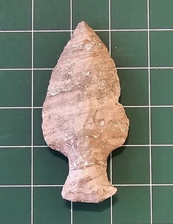
“We find artifacts on state-managed public land that span about 14,000 years of Michigan history, from stone spear tips and copper fish hooks many thousands of years old to the shoes and toys of children living in 19th/20th-century logging camps and industrial towns,” said Stacy Tchorzynski, director of archaeology at the Michigan History Center, an agency within the DNR.
Tchorzynski said her shop assisted the state land review by evaluating parcels proposed to leave state ownership for archaeological or other cultural resources concerns.
Lands with any such concerns are not made available for sale or, in special cases, are only offered to an alternate conservation owner. When any state-owned lands are sold, the state retains antiquities rights to help ensure the protection of important heritage.
“Archaeology represents our collective history, fills important gaps in oral and written records – and is often the only record available – and is a nonrenewable cultural resource,” she said. “Archaeological resources on state-managed public land cannot be disturbed or removed without a permit so that important places and information are preserved for future generations.
“We are proud to participate in the state land review so that Michigan’s important places are preserved for generations to come.”
New technologies, same goals
It’s important to remember this effort started at the height of the COVID-19 pandemic, so there was less face-to-face conversation with property owners and land managers, less walking of boundaries, and more reliance on technology, mapping and interactive information sharing.
Jeff Schmidt, a resource specialist in the DNR Forest Resources Division, said the state land review project was made possible because of the department’s web/geographic information system environment – GIS is the technology used by DNR land managers to help answer location-based questions.
“The platform functions as a website, so the teams involved could perform their work in easy-to-use mapping apps that open in a web browser,” he said. “These maps display department data over parcel boundaries, removing complexity from the task of analyzing data – like habitat or water access – to make informed recommendations about parcels. The platform allows managers to track progress on dashboards that present program statistics in real time.”
Additionally, the web-based approach gave people across the state an easy avenue to look at staff recommendations for each new group of land parcels and add their comments about specific locations right on the map. (Explore all the DNR’s publicly available map products and data sets at Michigan.gov/DNRMaps.)
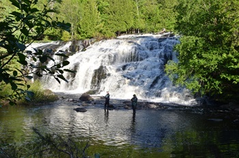
Darren Kramer is the manager of the DNR’s Northern Lake Michigan Fisheries Management Unit. His focus was on maintaining angler access to public waters while ensuring continued protection and enhancement of aquatic life and habitats.
From an internal perspective, Kramer said this state land review was considerably different from the last one completed almost 20 years ago.
“That review was mostly completed via in-person meetings with large paper maps that were spread out on tables, and all division staff discussed the various options for reviewing parcels,” he said. “This latest review was primarily completed through virtual meetings with several GIS-based mapping tools that greatly increased the speed and efficiency with which decisions could be made.”
The same communication goals held true, though.
Kramer said it was understood that all divisions have a responsibility to manage Michigan’s public trust resources, so if there were unanswered questions, the team had the freedom to contact field staff, sift through paper files or make field visits to better understand the full scope and value of parcels under review.
Community input
Throughout the 3.5-year review, communication with the public was essential. With every new grouping of counties, the DNR made use of several ways to connect with people, including traditional and social media, informative webinars, emails and the interactive web and mapping tools, as well as shared messages carried by local units of government and conservation partners.
“When it comes to making decisions about actions on DNR-managed lands, we try to involve the public as early as possible, sometimes a year or two or more in advance,” Heckman said. “These resources belong to Michigan residents. We want to hear those local details about the places people love and be certain that we’ve done everything possible to give opportunities for them to talk to us.”
The web-based map proved popular, with more than 20,000 views between
and , and 745 comments on land recommendations shared directly to the map. The counties with the highest concentration of comments were Chippewa, Ionia and Keweenaw.
The webinars were sparsely attended, but Seablom thinks that may have more to do with the fact that many of the land parcels under review were smaller ones or those fragmented from larger blocks of state forest land. Plus, human nature tells us that most folks aren’t compelled to act unless a decision directly affects them or their community.
“Regardless, it’s important to the DNR that the public knows we have a vested interest in making sure we’re caring for and conserving the lands under our management to ensure those lands will be just as valued as they are ,” Seablom said.
What’s next?
Although the official state land review has concluded, the implementation of the approved classifications for each parcel will be ongoing in the coming years.
That means working through proposed land exchanges, prepping and making parcels available at public auction, and working with alternate conservation organizations – units of federal, state or local government, land conservancies and trusts, and organizations that hold land for public benefit and protection – on parcels that were classified to be offered to them.
Parcels offered and accepted by alternate conservation organizations will stay open for public use and will be protected, and the DNR will retain any parcels that don’t have an alternate conservation organization interested in them.
It’s a painstaking, worthwhile effort that aims to match lands with the best-suited owners and caretakers for the best outcomes.
“Considering that the majority of state-managed lands were acquired haphazardly over the decades through the nonpayment of taxes, there truly are lands that are not benefiting the public and should be in private ownership,” Heckman said. “We are now much more thoughtful and strategic about land ownership, evaluating every DNR decision to know that we’re doing our very best to steward these invaluable, irreplaceable natural resources for the people of Michigan.”
Learn more about Michigan’s land strategy and the state land review process at Michigan.gov/PublicLands.

 DNR’s nearly four-year intensive land review effort recently completed
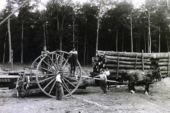 In the early 1900s and again during the Depression Era, a significant amount of land came into state ownership due to owners’ nonpayment of taxes. This most often happened after land was stripped of its timber resources or because of farm failures.
 More than 150 staffers across multiple DNR divisions played a role in the review, which was done on a county-by-county basis, 10 to 11 geographically dispersed counties at a time.
 “I took on the role of both local and regional reviews for a couple of reasons,” Cline said. “First, a state park unit’s area of responsibility is typically smaller than most divisions, which required more of our staff to be part of every review. Secondly, on the flip side, we also had to factor in statewide trail considerations and ongoing conversations with local communities for long-range planning.”
 Tom Seablom, the DNR’s western Upper Peninsula District forest manager, served as lead for the final field review within that district.
 In some cases, there was no question of whether to retain the land.
 Throughout the 3.5-year review, communication with the public was essential. With every new grouping of counties, the DNR made use of several ways to connect with people, including traditional and social media, informative webinars, emails and the interactive web and mapping tools, as well as shared messages carried by local units of government and conservation partners.
 Although the official state land review has concluded, the implementation of the approved classifications for each parcel will be ongoing in the coming years.


