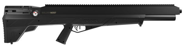
HatsanUSA Launches the Harpoon PCP Arrow Launcher
Rogers, AR – HatsanUSA is proud to unveil the Hatsan Harpoon, a revolutionary PCP arrow launcher that pushes the boundaries of airgun innovation. The Harpoon introduces a remarkable level of compatibility by seamlessly accommodating commercially available 20″ crossbow arrows (aluminum arrows with .30” inner diameter), eliminating the need for specialized and expensive ammunition. Acknowledging the Harpoon’s formidable power output, Hatsan recommends the use of aluminum arrows to ensure optimal performance.
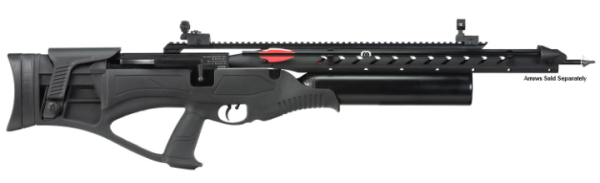
Boasting a bullpup design, side-lever action, and the advanced features of a pre-charged pneumatic (PCP) arrow launcher, the Harpoon stands as a testament to Hatsan’s commitment to pushing the limits of airgun technology.
The Hatsan Harpoon offers an array of cutting-edge features, including a patented gas piston hammer spring design for consistent power, 2-arrow storage for efficient reloading, and a locking elevation adjustable cheek rest for enhanced comfort and customization. The elevation and fit angle adjustable soft rubberized buttpad, along with the long combination optics rail accepting 11 mm and picatinny scope mounts, contribute to the rifle’s ergonomic design and adaptability. The 500cc aluminum air bottle ensures ample air capacity, while the 250 BAR fill pressure allows for swift and efficient refills.
With a hard-hitting maximum velocity of 600 FPS and a maximum energy of 330 FPE, the Harpoon delivers a powerful and dynamic shooting experience. The airgun provides optimal velocity for up to 10 shots, establishing itself as a reliable and efficient option for airgun enthusiasts.
Crafted with an advanced polymer in a tactical design and featuring an integrated pistol grip, the Harpoon’s stock contributes to enhanced control and maneuverability. With an overall length of 36″, a barrel length of 20″, and a weight of 9.5 lbs, the Harpoon strikes a balance between power and user-friendly design.
HatsanUSA invites airgun and outdoor sports enthusiasts to experience the cutting-edge technology and performance of the Hatsan Harpoon. For more information, product details, or to explore purchasing options, visit the official HatsanUSA website at https://hatsanairgunsusa.com/product/harpoon/.
Harpoon Features: Read more