MARK HARVEY State archivist, Michigan Department of Natural Resources
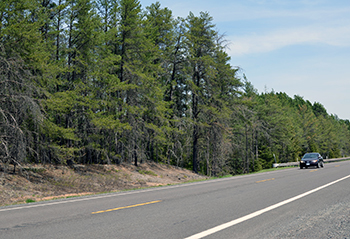
In 2011, ABC’s “Good Morning America” named Sleeping Bear Dunes National Lakeshore in Michigan’s northwestern Lower Peninsula the “Most Beautiful Place in America.”
But a hundred years earlier, at the turn of the 20th century, large swaths of northern Michigan looked bleak.
In a time before restorative forestry practices existed, lumber companies cut through tracts of virgin timber stands, leaving slash and stumps. Once the trees were gone, the companies moved on to another stand. In their absence, property taxes went unpaid and land values dropped.
However, in 1922, a team of state government and university officials launched a survey team to create maps that would change the trajectory of northern Michigan’s economy and launch the transformation of stump land into the “Water-Winter Wonderland” we know today.
The lumber boom in Michigan peaked in the 1870s and 1880s, but large-scale operations continued into the next century. Today, there are more than 800 logging and trucking firms, 300 wood product manufacturers and mills, and more than 3,000 secondary manufacturers who use wood resources to produce their products.
Lumber is still a viable, big business in Michigan because of improved forestry practices, but in the 1910s, Michigan stood at the precipice of 40 years of nonrestorative logging and lumbering practices.
Regrowing trees on cutover land or timber cultivation had yet to become a mainstream practice, and many Michigan counties teetered on the brink of insolvency from the unpaid property taxes of absentee owners.
Lumber companies and their workers provided the tax base for many communities, funding schools, infrastructure and local government operations. When the companies’ interests moved elsewhere, local governments were left holding the bill.
To make matters worse, lumber companies hired land speculation firms to sell the depleted acreage to get the worthless land off their books. They targeted unsuspecting people who wanted to be their own boss by running a farm in northern Michigan.
While vast tracts were available, the sandy soil produced pine trees, not traditional crops. Even if the soil was good enough to grow food or hay, the markets for goods were either too dispersed or too far away. Good roads to get products to main rail lines didn’t exist. The farmers who didn’t fail outright eked out a subsistence and couldn’t replace the lost tax base from the lumber companies.
The cutover land also presented an extreme fire risk. The stumps and brush left by large operations created a tinder box easily ignited by sparks from a locomotive or a lightning strike.
In 1913, the state geologist started to address the issue by convincing the Legislature to appropriate funds for a forest and soil survey, but World War I interrupted the funding. In 1917, the Michigan Legislature passed the Wiley Act to curtail the predatory land sales by speculation companies.
In 1921-1922, with the war over and the state geologist now in the new Michigan Department of Conservation (today’s Michigan Department of Natural Resources), he reprised the idea of the statewide survey.
At a forestry conference in 1922, the fast-rising conservationist P.S. Lovejoy championed the survey saying, “Nearly a third of all the land in Michigan has been repeatedly cut and burned over and is now producing little or nothing in taxes or anything else.”
Lovejoy shared that financially stable counties had almost three times the education funding per student. Public education in Michigan is funded by property taxes. He continued to press his point.
“These conditions have been denied or winked at rather than offend local pride and because of a vague hope or theory that somehow profitable uses for the idle land would be found,” Lovejoy said.
His solution was the economic survey. Lovejoy argued that the state needed to encourage the cultivation and growth of timber as a sustainable resource and a source of tax revenue and that a new survey could help reassess the value of the cutover land, balancing the local tax base and ultimately providing education funding.
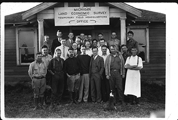
Lovejoy helped launch the Land Economic Survey in 1922 as a partnership between the Michigan departments of Agriculture and Conservation, Michigan Agricultural College (now Michigan State University) and the University of Michigan.
The initial survey included Charlevoix County and then expanded, under Lovejoy’s direction, to neighboring counties. In 1923, the United States Senate Committee on Conservation met in Michigan and encouraged the state to continue funding the survey as a model for the rest of the nation.
The survey crews worked hard. A typical crew surveyed 3 to 6 miles a day. There were two crews, each with a chief assistant who oversaw two field captains. The field captain supervised four foresters and four agronomists. These experts were skilled in the growing of trees or soils and the cultivation of crops. The crews also had a couple cooks on staff to keep the workers fed in the field.
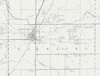
Unlike with the original surveys of the state that focused on the boundaries of counties and townships, the Land Economic Survey crews noted soil and timber types; bodies of water including streams, rivers and lakes and cultural features, including towns, schools, churches, cemeteries, resorts, mines and lumber camps.
From the initial survey, the team created a base map that other professional engineers and biologists used to create additional layer maps, including soil surveys, cultural features, farms and forests, and maps for hunting and fishing. The team also set up agricultural experiments in certain counties to provide real-time data on crop viability.
The survey work continued into the 1930s, until the Great Depression hampered its progress. The soil surveys continued until 1960, but the story doesn’t end there.
The economic legacy of the survey allowed state and local officials to regain some control of a situation in free fall. While it didn’t solve every economic problem, the survey provided a literal map for the region’s economic future.
Now, 100 years later, the maps serve as a valuable historical resource to view the Michigan cultural and natural landscape. Researchers can compare changing forest types and agriculture, verify ghost town and lumber camp locations, track down cemeteries of family members or locate one-room schoolhouses.
The surviving maps and the records of the Michigan Department of Conservation are available for research at the Archives of Michigan in Lansing.
Check out previous Showcasing the DNR stories in our archive at Michigan.gov/DNRStories. To subscribe to upcoming Showcasing articles, sign up for free email delivery at Michigan.gov/DNR.
Note to editors: Contact: John Pepin, Showcasing the DNR series editor, 906-226-1352. Accompanying photos and a text-only version of this story are available below for download. Caption information follows. Credit Michigan Department of Natural Resources, unless otherwise noted.


 The cutover land also presented an extreme fire risk. The stumps and brush left by large operations created a tinder box easily ignited by sparks from a locomotive or a lightning strike.
 Lovejoy helped launch the Land Economic Survey in 1922 as a partnership between the Michigan departments of Agriculture and Conservation, Michigan Agricultural College (now Michigan State University) and the University of Michigan.


