From – Paul Erhardt, Managing Editor, the Outdoor Wire Digital Network
One of the most valuable hunting tools available today is the GPS.
The ability to identify exactly where you are out in the wild, where your best hunting spots are, where your game cameras are, and where your hunting buddies are, is critical both for a successful hunt, but also from a safety standpoint.
Long gone are the days of carrying a compass and having to master land navigation – though that’s a helluva skill to have, so don’t dismiss the old school approach.
Today’s hunters have gone high-tech. And with the nearly universal acceptance and use of smartphones, with their built-in GPS capability, the phone is replacing the handheld GPS in locales where cell service is available.
Why carry a specific piece of additional gear whose tech is already replicated on your phone? Especially if it’s on your phone in the form of an app that is designed for hunting.
For hunters of all skill and experience levels the onX Hunt app is an ideal solution for searching and mapping your hunts. And because it sits right on your phone it adds exactly zero extra pounds, or even ounces, to your hunting load out.
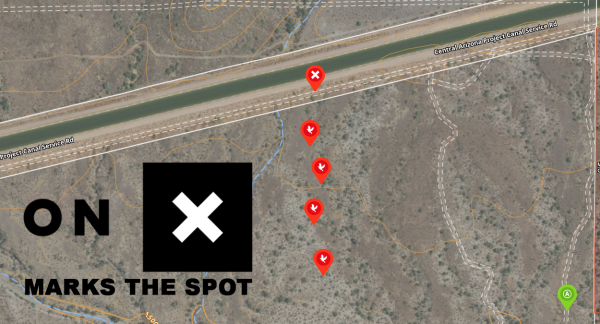
I have the onX app, and I use it. I am far from a super-user because my needs are fairly limited in scope. As a dove hunter I need to confirm my distance from the nearest structures and roads. I also need to mark my hunting spots, though none are what I would call a ‘prime spot.’
And since I live in Arizona, and I need to be out there and ready to hunt 30 minutes before sunrise, it’s kind of important I have my route mapped out. I am not hunting in a sunflower field – or any kind of field for that matter – but in the desert. A rocky terrain pockmarked with areas of uneven footing due to monsoon season erosion.
I prepped specifically for dove season the first year I used the onX app by walking the best, least restricted route to my spot and marking key points along the way so I’d know I was on the right path and not about to stumble down a four-foot drop in the dark to take a face full of rocks, or worse, cactus.
Knowing exactly where I was going in the early morning darkness is arguably a trivial thing, but after several seasons of high school basketball I have become a big fan of no spraining my ankle…particularly if it happens to be on Opening Day.
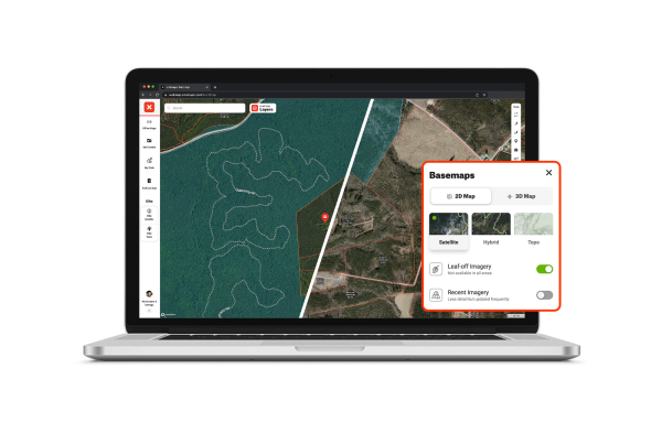
onX has two tiers for their Hunt app. The Premium level is what I used in the past and is limited to a single state for a $29.99 annual fee. This gave me access to Arizona’s land ownership maps, 3D, satellite, topo, and hybrid basemaps.
It also allowed for offline maps, customizable waypoints with optimal wind and is accessible on iOS and Android phones, as well as a desktop.
However, for this upcoming dove season I will be using the Elite membership version of the app which has several more features starting with access to nationwide land ownership maps, and Canada hunting maps…not that I plan on hunting in Canada, but one never knows.
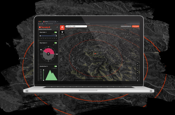
The Elite membership has other advanced tools such as their Terrain X 3D Viewer, recent imagery, and Route Builder.
The Elite membership is $99.99 annually, and while it is far more than I need it does give me some cool features to test. The route builder is top of my list of features to try since with the Premium version I just dropped waypoints, which certainly worked but this will be better.
onX has recently announced a host of new features available in the app, and while they may be a bit of overkill for my purposes, they will be a welcome addition for hunters who are far more serious about hunting season than I am.
The new features available in the onX Hunt app are a veritable smorgasbord for hunters looking to maximize their time in the field.
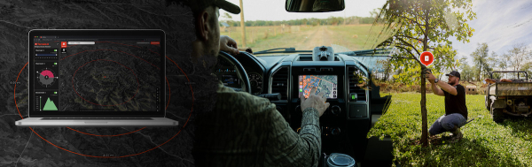
One of those new features I can see being a huge hit is the onX Hunt app is now available in the dash of Apple CarPlay-enabled vehicles, with Android Auto soon to follow. In-dash integration of the hunting app is an obvious benefit for the hunter but also for friends and family members needing to locate that hunter in an emergency.
Another major addition to the capabilities of the onX Hunt app is that members can pinpoint trail cameras on their map and directly import (via the memory card) each camera’s imagery, storing all their intel in one app. This process is currently available via the onX Hunt Webmap and will be available via mobile app later this summer.
Even better news for the avid trail cam user is that onX is working with makers of cellular equipped camera brands to allow for a more streamlined integration with the app. I am told the first camera brand will be announced in a few weeks.
I obviously don’t need a trail cam for dove but even I can see the appeal of this feature for the small and big game hunters.
onX’s Imagery on Demand feature offers Elite members the ability to order custom, high-resolution satellite images of their hunting grounds and stitch those images onto their map. These detailed perspectives allow hunters to see current conditions, such as habitat management improvements on their whitetail property, or make critical and time-saving decisions, like whether a go-to duck pond has melted in a neighboring state.
Other upgrades include their TerrainX, which is onX’s first proprietary 3D mapping and analysis tool that allows Elite users to narrow in on potential hunting and habitat areas by filtering for slope aspect, angle, and elevation.
TerrainX allows you to do a deep dive into the terrain of your potential hunting locations.
The new Recent Imagery and Historic Look Back feature delivers recent medium-resolution imagery giving hunters an idea of what the terrain looks like now, and what it looked like “then.” Updated every two weeks, Elite members can scroll through previous weeks to get a historical sense of their hunting area’s macro trends – such as snow lines, agricultural work, timber cuts, water levels, and fire impact over time.
I am guessing this feature might be handy for the dove hunter who wants to know if their favorite spot is now a drainage runoff for a new housing development. This is actually a legit concern for me here in the Phoenix Valley.
While we don’t have this particular concern in the desert, the new Leaf-Off Imagery provides the perspective of seeing a hunting area without the interference of foliage and undergrowth. This high-resolution perspective is initially available for southern and eastern states, and will be available later this month to Elite members.
The ability to view your hunting territory through the canopy of leafy foliage is, well, a little like cheating. OnX’s Leaf-Off Imagery is akin to running the app in ‘God mode’ pulling back the view of Mother Nature.
Finally, the 3D Mode, previously accessed via the Webmap, is now available on iOS. The 3D Elevation Exaggeration feature will also be available on mobile devices later this summer. This feature, currently accessed via the Webmap, provides comprehensive terrain analysis in places with subtle elevation changes.
As onX Hunt’s General Manager, Clifford Cancelosi, noted when the company announced the upgrades, “successful hunters need to know their terrain inside and out. We’re investing in imagery and powerful tools that give hunters boots-on-ground knowledge they can access from anywhere, year round. So whether you’re scouting a new area or looking for that perfect treestand location–all the information you need is at your fingertips.”
Clearly these are all very high-tech hunting features that one doesn’t really need for hunting dove, which is a very stupid bird. But for dove hunters the onX Hunt app is a great tool to have. I, for one, now depend on it.
If you haven’t already jumped on the onX Hunt bandwagon, and are still wondering if it’s for you, you can start a free trial and receive their Premium member features for seven days. I really don’t think it will take you seven days to figure out how valuable a tool this is. It sure didn’t take me seven days, not even seven hours.