By Glen Wunderlich
Charter Member Professional Outdoor Media Association (POMA)
Brad Reynolds is nuts about trout fishing. After purchasing a used, fiberglass drift boat for $6,000, he had second thoughts when it began to delaminate and it needed new gelcoat in a short two years of use. That’s when his thoughts turned to building his own boat from wood, which he states is warmer than fiberglass and quieter than aluminum. The astounding results not only turns heads, but the custom vessel was produced for approximately one third the cost of other options.
In his spare time, Brad is employed by Sparrow Hospital in Lansing as a cardiovascular technician and also enjoys anything related to fly fishing including fly tying, and custom, split-bamboo rod building. Yet, in his garage some 20 years ago, he found time to build his vision in one summer! Although information indicated that one can build such a boat in 40 man-hours, it took him about five times that amount.
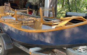
Brad Reynolds’ Dory
Says Brad: “As someone who over-estimates the technicalities of such projects, I researched the time investment, materials, epoxies and tools. Everything I read said nothing of the fine carpentry skills and precise measurements required for boat building. In fact, the reading was quite to the contrary. As a boat constructed of a stitch-and-glue technique, most of the precise cuts are eliminated, because gaps are filled with epoxy, fillers and fiberglass cloth.”
The plans were from a professional boat builder, Jason Cajune, of Montana Boat Builders (www.Cajuneboats.com). Brad chose the river dory (a flat-bottom boat with no keel) for its ease in rowing against current. The oars are nine feet in length and are constructed of carbon fiber and counter-balanced with floating blades to keep the rowing comfortable. “These boats will maintain their position in a river with very little effort, while allowing the angler post up for multiple shots toward a rising fish or structure” according to Brad. 
The skin for his boat is made with 3/8-inch exterior-grade plywood; the bottom is ½-inch exterior ply with emphasis on waterproof glue. (Another more expensive option is to use marine plywood for additional strength and a rich mahogany finish.) Trim pieces were made of ash wood – a hardwood for wear and durability without the oils of oak, which can interfere with the epoxy and the bonding process. The floor is treated with exterior enamel paint, which can be touched up easily.
The boat was designed with an abundance of storage options for a grill, cooler and additional bags without cluttering the floor.

9-Foot Oars
The anchor rope travels in a race under the floor to keep the rope clear from predictable, unwanted results. The bottom’s exterior has a Teflon additive to the finish coat to help the boat slide off river obstructions.
Most dories are not motorized because they cannot get on plane and push too much water to be efficient. At the same time, the 400-pound boat requires no registration or license per Michigan boating laws, because it is16-feet in length and not motorized.
Brad estimates today’s cost depending on wood options and finishes would be between $1100 to $1350 plus the cost of a trailer and anchor – a far cry from the market price of a finished boat.
Brad estimates the vessel has logged over 1,000 hours on the waters of Michigan’s AuSable, Grand, Muskegon and Pere Marquette rivers and with its recent renovation is equipped to do it all again.
I’ll add this bit of personal experience to fishing in this type of boat: With a most experienced guide and operator years ago, I was free to cast dry flies onto the surface of Utah’s world-famous Green River. Guide, Lyle Waldron, knew the turns, rocks and holes and put me on them and it all added up to a fishing experience of a lifetime. The design allows people to fish standing up – good for spotting and a pre-requisite for unencumbered casts.